The concept for developing a Lake Protection Node zoning district is primarily based on the Smart Growth principle of allowing mixed land uses to create more vibrant, diverse, and walkable communities. The provision of active living opportunities, where residents and visitors can easily and regularly walk or bicycle to everyday destinations, supports healthy movement and can lower health care costs. Local areas like Midtown and Market Square have a mix of commercial, office, and residential uses, and are arguably some of the most attractive areas to shop, live, and invest in locally.
Development concentrated into geographic nodes is a planning tool which is gaining popularity both locally and elsewhere. The concept involves allowing higher development rights around major intersections rather than along commercial strips that stretch miles down either side of roads. Such nodes, through concentrating commercial, office, and higher density residential uses tied together with sidewalks and bicycle lanes and paths can help reduce automobile trips, decrease the need for widened roadways to accommodate these trips, and provide convenient and attractive walking and bicycling connections to adjacent or nearby residential areas.
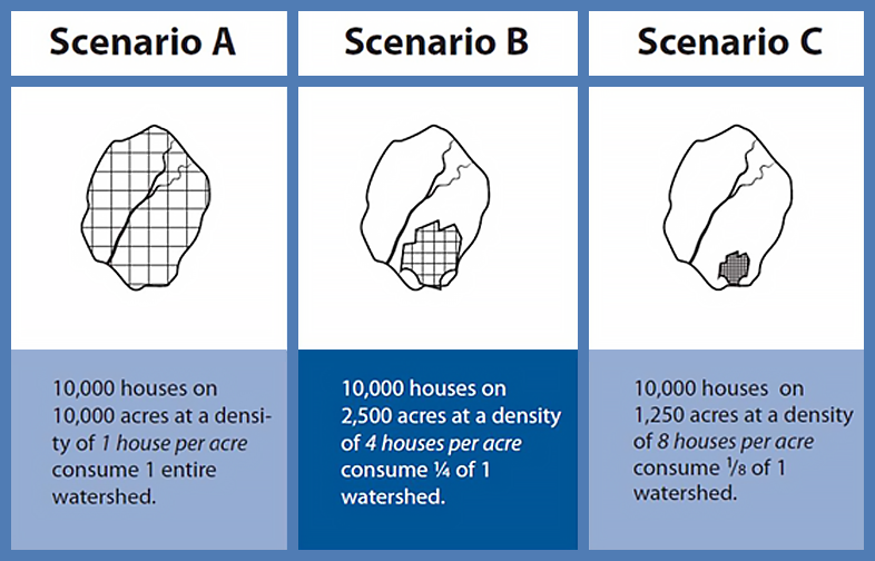
The 2006 U.S. Environmental Protection Agency report "Protecting Water Resources with Higher-Density Development" focuses on the idea that more compact development can help save more land to protect water resources. The following graphic from the report demonstrates how the same number of homes can be accommodated in less land area when the land per home is reduced. The graphic is simplified to help illustrate the concept. County staff recognizes that the Lake Jackson basin is complex and that significant development already exists in the basin. However, this concept can still be utilized in new policies to guide future development toward designated nodes
An emerging urban node (the Lake Jackson Town Center) has been identified by the County at the intersection of U.S. Hwy 27 North and Fred George Road. As part of this recognition, the County in turn constructed the new Lake Jackson Branch Library, and supports the Sense of Place planning initiative for this area. This support includes $100,000 approved by the Board to implement the plan for the Lake Jackson Town Center Sense of Place Initiative. The funding for this project is available in the Fiscal Year 2014 budget.
Other local examples include the Mahan Gateway Nodes as identified on the Comprehensive Plan's Future Land Use Map. These nodes were created based on community concerns that the recently widened Mahan Drive would eventually become lined with a strip of commercial uses similar to West Tennessee Street or Apalachee Parkway.
Land uses are significantly limited in Lake Protection. The incorporated area of Lake Protection (within the City Limits) does not presently allow non-residential uses. The unincorporated area allows some non-residential uses (minor office and minor commercial), but only within a Planned Unit Development process that requires Board approval.
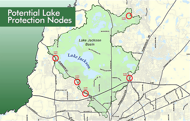
The establishment of nodal areas by the application of a new zoning district could be allowed at identified intersections of major roadways similar to that established along Mahan Drive between Capital Circle and Interstate – 10. Potential locations are identified on the following map with ¼ mile radius circles and may include U.S. Hwy 27 and Capital Circle Northwest, U.S. Hwy 27 and Fred George Road, U.S. Hwy 27 and Sessions Road, the Market Square area, and the intersection of Bannerman and Bull Headley roads.
This new zoning district would specify permitted uses, and urban design and other development standards, including current Lake Protection stormwater standards and requirements and perhaps a cap on total acres in the Lake Jackson Basin that can be placed in the new district. Properties that could be considered for rezoning to new Lake Protection Node would include non-conforming uses, vacant properties whose highest and best use may be commercial or office to serve the surrounding residential areas, and other properties suitable for higher density housing. The extent of these nodal areas would ideally be within a radius of ¼ mile of a main intersection, which is a five-minute walk for most people.
The Lake Protection Node zoning district is consistent with the following Smart Growth principles:
- Compact building design
- Range of housing opportunities and choices
- Walkable neighborhoods
- Sense of place
- Direct development towards existing communities
- Variety of transportation choices
- Make development decisions predictable, fair, and cost effective

Sustainable Growth
The 1987 World Commission on Environment and Development established the most often used definition of sustainable development: "development that meets the needs of the present without compromising the ability of future generations to meet their own needs." While this definition is widely utilized, it is challenging to directly apply to policy decisions. As such, the definition has been the subject of many efforts to develop implementing principles.
The Planning Department selected "Smart Growth" as the body of work and implementing principles to provide a framework for this project. The Smart Growth principles were established by the Smart Growth Network in 1996 and were the subject of four publications developed cooperatively with the International City/County Management Association. The Smart Growth Network has a broad partnership base including the National Association of Counties, ICLEI-Local Governments for Sustainability, Institute of Transportation Engineers, American Planning Association, Florida Department of Health, and the National Association of Realtors. Both Leon County and the City of Tallahassee are members of ICLEI.
The Smart Growth principles were selected for this project based on the quality of the information available, specific focus on local government, broad support, and consistency with existing Comprehensive Plan and County Commission direction.
The ten Smart Growth principles identified by the Smart Growth Network include:
- Mix land uses
- Take advantage of compact building design
- Create a range of housing opportunities and choices
- Create walkable neighborhoods
- Foster distinctive, attractive communities with a strong sense of place
- Preserve open space, farmland, natural beauty, and critical environmental areas
- Strengthen and direct development towards existing communities
- Provide a variety of transportation choices
- Make development decisions predictable, fair, and cost effective
- Encourage community and stakeholder collaboration in development decisions
These principles, Planning Department analysis, and the policy examples provided in "Getting to Smart Growth: 100 Policies for Implementation" and "Getting to Smart Growth II: 100 More Policies for Implementation" were used to develop the concepts for the Lake Jackson Sustainable Development Project.
Sidewalks in Lake Protection
Walkability is more than just sidewalks, but they are fundamental to being able to walk to a destination within urban areas. At present, Section 10-7.529(3)f of the County's Land Development Code exempts sidewalks in new residential developments within the Lake Protection zoning district. This portion of the project will review the existing sidewalk exemption in Lake Protection and evaluate the potential use of locational standards such as proximity to the Lake Protection Node zoning, potential connection to existing or proposed sidewalks or greenways, and sewer availability to determine when sidewalks would be required. Options may include retaining the exemption for isolated residential areas with little or no walkability potential.
Both the City and the County are retrofitting certain urban areas with sidewalks where feasible and affordable. These include proposed sidewalks within the Lake Protection district along Maclay and Timberlane roads. The recently updated City/County Greenways Master Plan also proposes several multiuse trails that have the strong potential to improve pedestrian and bicycle connectivity in areas of the Lake Protection district. Requiring new development in potentially walkable areas to install sidewalks will help prevent these costs from being shifted to future tax payers in from of public projects.
The benefits of walkability include the ability to age in place, lowered transportation costs, improved personal health and fitness, and expanded choices on how to get around.
Current Residential Density, Land Uses, and Concept for Change
The allowable residential density within the Lake Protection Future Land Use Category is intended to limit development within the drainage basin to large residential only lots. At the time this policy was adopted (1990), this was considered the best way to protect water bodies from the impacts of development, especially in more rural areas. However, such low-density residential areas are typically automobile-dependent, which requires impervious surface areas such as roads, driveways, and parking areas that generate higher per-person environmental impacts. Additionally, impervious areas can increase in such areas by the construction of large houses and large fertilized lawns to match the required large lot size.
Land Uses
The existing land use pattern within the area designated Lake Protection in the Comprehensive Plan is dominated (in order of acreage) by residential, open space, and vacant lands. Only 1.5 percent of Lake Protection is developed with office, retail, and multi-family.
Another way to look at land use is to sum the number of parcels in each land use type. This data can help identify the presence of uses that may include numerous parcels but represent a very small percentage of acreage, or reveal uses that have a high percentage of land area but are contained in a small number of parcels (such as parks).
Based on the existing land use data, it is clear that Policy 2.2.18[L] has met its intention of creating a low-density, large-lot suburban residential pattern for most the developed areas in the Lake Protection category. However, approximately 25 percent of the Lake Protection area is currently either vacant or has potential for redevelopment at a higher density (large lot with home category).
Residential Density
The Lake Protection policy allows for one residential unit per two acres. The existing net residential density (residential units / residential acres) is slightly more than one residential unit per one acre. This higher density (twice the allowed amount) is the result of smaller lot development that occurred prior to adoption of the Lake Protection policy in 1990.
In contrast, the Comprehensive Plan calls for an Urban Service Area average of no less than two residential units per one acre, which is four times the allowed density in Lake Protection. However, the current Lake Protection policy does not support the larger goal of more compact development in the Urban Service Area.
Concept for Change
Given that all of the Lake Protection designated lands are within the Urban Services Area it is logical to consider targeted areas for higher density residential and the inclusion of office and commercial uses. Nevertheless, in order to avoid impacting the water quality of Lake Jackson any further, any significant increases in impervious surface, particularly within more intensely developed sub-basins, must be limited and/or mitigated. Mitigation measures may include offsetting water quality improvements from existing impervious areas, new or strict enforcement of existing development requirements that may require additional buffers, additional or alternative treatment of stormwater and wastewater to reduce nutrients, or other measures such as retrofitting of existing areas and redevelopment incentives that focus on stormwater quality treatment.
In sum, the existing homogeneous, large-lot development patterns within Lake Protection tend to be automobile dependent, consume significant quantities of land, and require significant impervious areas on a per-capita basis.
Additionally, the constraint upon non-residential uses in Lake Protection, that market forces would tend to foster at nodes consisting of major intersections, forces this development to areas farther away and reachable only by automobile.
Given these issues, it is rational to consider new methods to allow for a more sustainable development pattern in this area that also protects the water quality of Lake Jackson. Targeting areas based on Smart Growth principles is intended to help support larger goals for a compact community that preserves green space and rural lands further from the urban core.
What is the Lake Protection Zone?
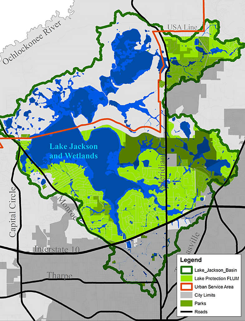
Two overlapping areas are used to discuss Lake Jackson in this project. First is the Lake Protection Future Land Use Map category, as mapped and defined in the Tallahassee-Leon County Comprehensive Plan. The Lake Protection category is approximately 10,000 acres in size and was established as "a protection category that is specific to the well documented scientific concerns regarding the degradation and continuing pollution of Lake Jackson" (Policy 2.2.18 [L]). The second area utilized to discuss Lake Jackson is the approximately 27,000 acre full drainage basin for Lake Jackson. The full drainage basin is used to discuss items such as total impervious area draining to Lake Jackson and the Lake Protection Future Land Use Map category is used to discuss policy recommendations.
The following map provides a visual display of how the smaller Lake Protection category fits inside the larger Lake Jackson drainage basin. The Lake Protection category excludes the more intensely developed areas south of Interstate-10, predominantly inside the City Limits. The category also excludes a large section of the northwest portion of the drainage basin that is outside the Urban Service Area and not currently intended to be scheduled for urban activity.
Identify Non-Conforming Land Uses
There are a number of non-conforming land uses (uses that do not conform to the existing requirements) throughout the Lake Protection district. Office and retail uses are the most common non-conforming use. While developing the Lake Protection Node zoning district concept, County staff will seek to address many of the non-conforming uses by proposing their rezoning to Lake Protection Node. Non-conforming uses located outside of logical node areas will need to be evaluated for other possible treatments to protect owner investments or transition the use to conform to Lake Protection. Some options may include certificates to document legally established uses, requiring Planned Unit Developments, policy changes to allow specific uses within conditions, or required phase-out of the non-conforming use.
This process of identifying remaining non-conforming uses will be conducted later in the project after the Lake Jackson Node zoning district is written and potential areas to include in the new district are identified.
Impervious Area as a Predictor of Stream Health
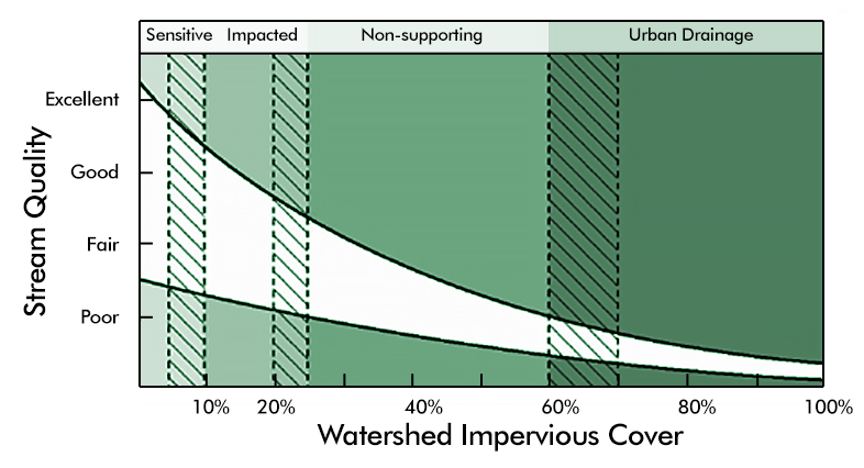
Impervious areas are structures such as pavements and buildings that do not allow rainwater to pass through into the ground. Impervious areas increase the speed and amount of stormwater runoff resulting in impacts to streams. There is a body of research that has established a relationship between the amount of impervious area in a watershed and the receiving stream quality. While stream quality may vary based on other factors, such as forest cover, agriculture and road density, there is general agreement that watersheds with impervious areas from 10% to 20% will show clear signs of declining stream health. County staff will continue to utilize this information to help guide recommendations on the scale of any development regulation changes based on Smart Growth principles.
The following chart from the June 2013 U.S. Environmental Protection Agency report "Our Built and Natural Environments: A Technical Review of the Interactions Among Land Use, Transportation, and Environmental Quality" depicts the relationship between stream quality and watershed impervious area. The white cone represents the variability in the response of streams to different levels of impervious area (higher variability in watersheds with a small percentage of impervious area). As the percentage of impervious cover in a watershed increases, stream quality declines. The hatched areas indicate that the transition point between stream quality classes is not a precise percentage or break point (originally published in 2009 by Schueler, Fraley-McNeal, and Cappiella, American Society of Civil Engineers).
Relationship Between Stream Quality and Impervious Area
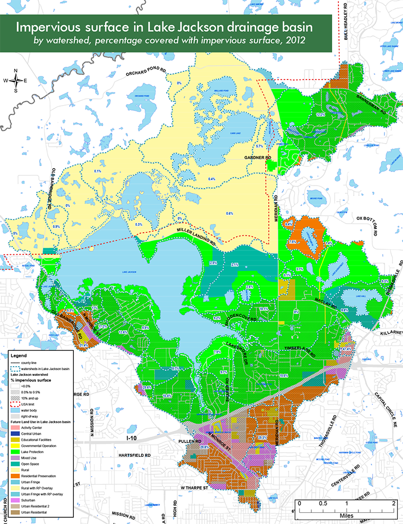
The following map provides the percent impervious area in six sub-regions in the Lake Jackson drainage basin. The impervious area in these sub-regions ranges from 1.5% to 22.6%, with the full Lake Jackson basin containing 9.1% impervious area. The higher percentages of impervious area occur south of Interstate-10 in the areas excluded from the Lake Protection category. The lowest impervious areas occur in the northern portions of the basin that are outside of the Urban Service Area.
Common Cluster Development
Compact building design not only means allowing smaller buildings on a given parcel or lot, but reducing lot sizes, and allowing taller buildings. Compact building design can result in more walkable, diverse communities that also preserve open space, farmland, natural beauty, and critical environmental areas.
The Lake Protection land use category in the Comprehensive Plan (Policy 2.2.18 in the Land Use Element) currently specifies a base density of one residential unit per two-acres (~2 acre lot size). This large lot size was used partly based on the idea that lower-density housing equals less impervious surface. However, in practice, large lot sizes often result in large quantities of land being cleared, affecting runoff and natural habitat, and also requiring an extensive road network due to the distance between homes.
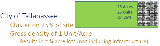
To address this issue and to give landowners and developers some additional alternatives, two cluster options are currently provided for in Policy 2.2.18 [L]. A cluster option is available within the incorporated area that allows a residential density of one unit per gross acre if the resultant development clusters the units on 25% of the property, and maintains the remaining 75% in natural open space. The following graphic provides an example on a 25 acre site.
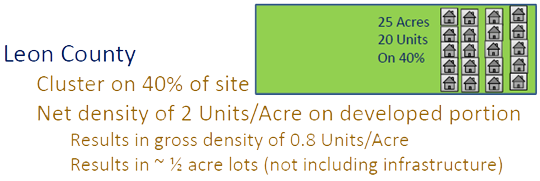
The cluster option in the unincorporated area of the Lake Protection category allows the development of 40% of the site at a net density of two units per acre on the developed portion of the property. The remaining 60% of the property must remain in natural open space. The minimum lot size under this cluster option is 1/2 acre. The following graphic provides an example on a 25 acre site.
County staff was unable to identify a currently applicable rationale for two different cluster options given that sewer is available in a significant portion of the vacant, developable land area within Lake Protection, and these areas are all located within the Urban Service Area. This portion of the project will seek to propose a common cluster development option for both the incorporated and unincorporated areas that also incentivizes use of the cluster option.